|
Origins of a Tornado & optimal weather conditions
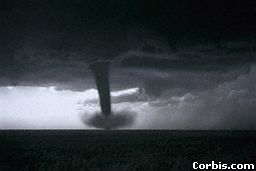
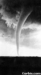
The distinguishing feature of the tornado is the funnel. The visible funnel is formed by the condensation of water vapor resulting
from the lower pressure within the whirl and from debris drawn into the spinning mass as the size and strength of the funnel
increase
Several funnels may develope in a mature tornado system, with small vortices continually forming and dissipating while
whirling around the central core of the main tornado circulation. A tornado funnel can assume various forms, from a thin,
writhing, ropelike column of grayish white to a thick, amorphous mass of menacing black.
In the Northern Hemisphere, tornadoes almost always spin counterclockwise, although verified instances of clockwise circulation
have been reported. Films of tornadoes haverevealed that the visible flow on and just outside the funnel surface is nearly
always spiraling upward.
In recent years, the exact mechanism that causes a tornado to form, called 'tornadogenisis,' has been the subject of increasingly
fruitful research. Nevertheless, some mystery still surrounds tornadoes, and their formation cannot be predicted with absolute
accuracy, even when conditions for their occurance seem just right.
Tornadoes are usually associated with thunderstorm conditions. They require a moist airstream that is warm for the season
and usually comes from a southerly direction. A 1986 survey has shown that most tornadoes occur when air temperatures are
above 65 degrees F and the dewpoint (temperature at which condensation begins) is 50 degrees F or higher.
Sometimes a tornado is formed by a small cyclonic circulation, called a mesocyclone or tornado cyclone, embedded in a
larger storm circulation. Mesocyclones are about ten miles in diameter and contain miniature cold and warm currents that interact
to form a tornado funnel.
Certain atmospheric conditions are conductive to the formation of tornadoes. One such condition is a teperature structure
of the atmosphere in which warm air overlies cold air (called an inversion). Inversions inhibit verticle currents and help
maintain the concentration of low-level moisture.
The early pesence of the inversion also prevents deep convection from dissipating heat energy upward. At intermediate
levels of the atmosphere, a warm, dry layer usually has an air movement from the southwest: at high levels, a strong westerly
flow with jet stream characteristics prevails. A graphic cross section of the entire mass of air would show deep convective
instability, with large drop-offs of temperature and moisture through a great depth.
Dynamic lifting in rising air currents soon destroys the inversion. Strong low-level vertical wind shear and a low-level
jet flow assist in tornado formation
The contraction of the tornado cyclone into a tighter circle causes increasing wind speeds, which leads to decreased air
pressure inside the cyclone and more violent updrafts. This process, known as the conservation of angular momentum, can cause
winds of 50mph to 250mph: the process works in much the same way ice skaters preforming spins increase speed by drawing their
arms in tight to their bodies.
Direction of Movement: Generally speaking, 87 percent of all tornadoes have preferred directional movement, which is
from southwest to northeast. Rarely do tornadoes move toward the west. Some tornadoes, however, have been reported to move
from any quadrant, change directions abruptly, follow zig-zag paths, become stationary, or perform loops or complete circles.
(National Audubon Society: Field Guide to North American Weather; pg.111)
|